A Working City
Mandalay is less photogenic than Bagan and more interesting to spend a day in, because everything the temples are made of is still being made here.
The Craft Streets
Whole blocks here do one thing. Gold leaf is beaten by hand near the Mahamuni, long shifts of hammering that reduce a gram of gold to sheets thin enough to lift on a breath. Marble carvers work an entire street towards the hill, cutting Buddha images from Sagyin stone under white dust and the noise of angle grinders. Both are open to watch.
Hill And Stairways
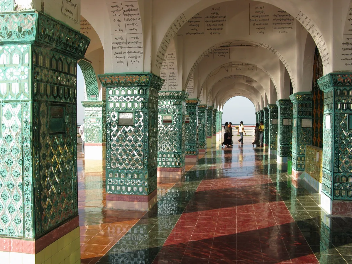
Mandalay Hill rises about two hundred and thirty metres straight off the plain at the north-eastern corner of the moat. Four covered stairways climb it, barefoot, past shrines and snack sellers and mosaic-lined pavilions, in roughly half an hour. There is also a road and a lift. Walking is better, and what you get at the top is the moat and the river rather than a view.
Teak At Amarapura
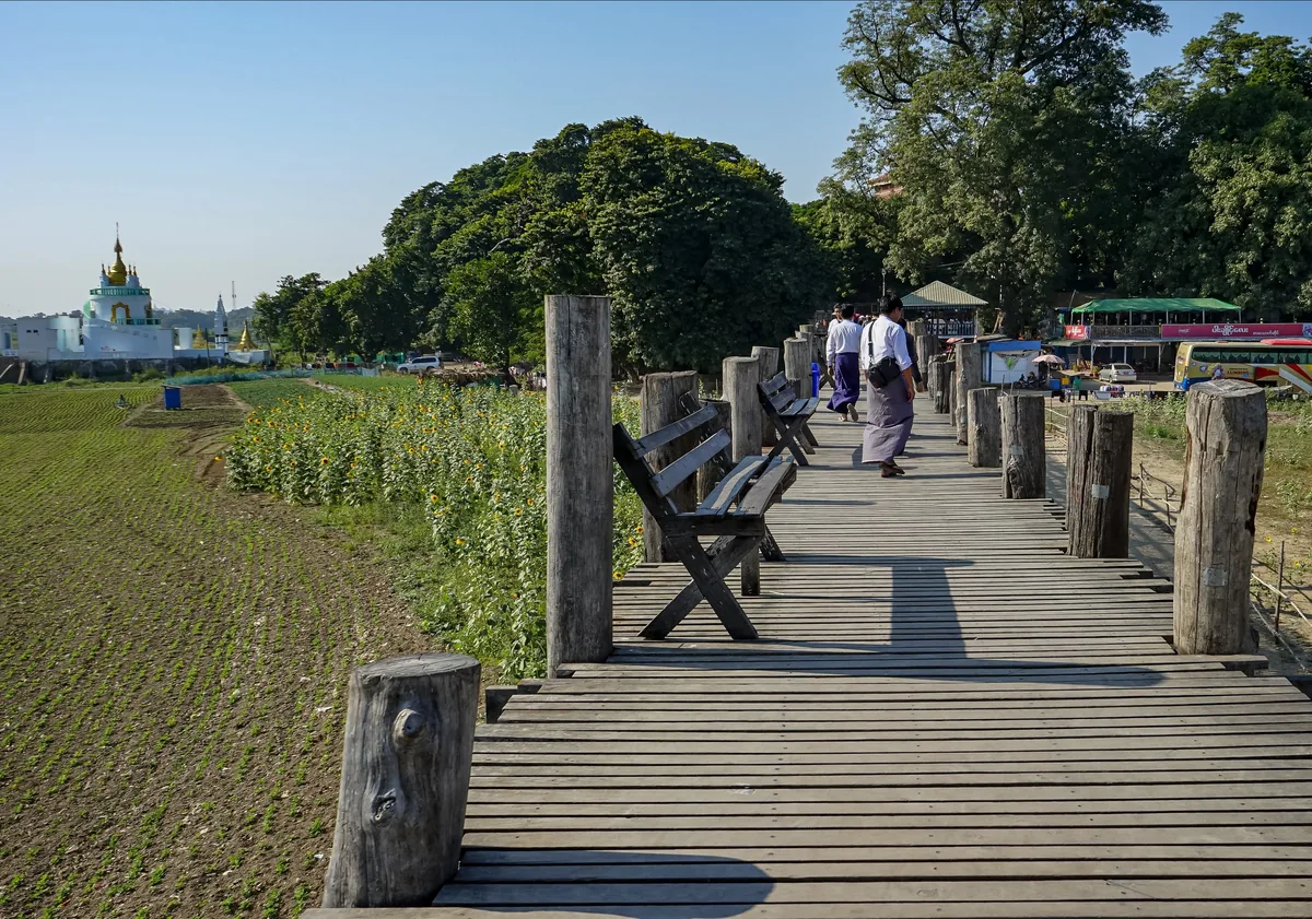
U Bein bridge crosses shallow Taungthaman Lake on more than a thousand teak posts for something over a kilometre, built in the mid-nineteenth century from timber taken out of the abandoned palace at Inwa. It is a working footpath, used by monks, cyclists and people carrying vegetables to market. The March 2025 earthquake damaged sections of decking, and repairs have been running since.
Top Highlights
- Watch gold leaf beaten by hand near the Mahamuni, where a single gram of gold is hammered for hours into sheets that lift on a breath.
- Arrive at the Mahamuni before dawn for the washing of the image’s face, a ritual repeated every morning for well over a century.
- Read the outside of the largest book in the world at the Kuthodaw, 729 marble slabs of Pali scripture, each in its own white stupa.
- Climb a covered stairway up Mandalay Hill barefoot in the late afternoon, past shrines and mosaic pavilions, in about half an hour.
- Look closely at the Shwenandaw Monastery, the one building of the teak palace to survive, because it was dismantled and moved outside the walls in 1880.
- Cross U Bein bridge at first light with monks and market traders, before the boats and the camera crowds reach the far end.
Region
Mandalay Region, upper Ayeyarwady
Airport
Mandalay International (MDL), 35km south of the city
Best Months
November to February; severe heat from March
Suggested Stay
Two nights, three with the old capitals
Known For
Gold leaf, monasteries, craft workshops
Pairs With
Bagan, Yangon, Inle Lake
Mandalay is Myanmar’s second city and the commercial and religious centre of the north, with well over a million people in the urban area. It is laid out as a grid of numbered streets around the square moat of the royal palace, which takes up more than four square kilometres in the middle of town and remains an army compound — so the grid bends around a hole you cannot cross.
It is a working city rather than a handsome one: low concrete blocks, heavy traffic, jade traders, timber yards and workshop after workshop. Overland trade with Yunnan runs through here and shows itself in the shopfronts and in the languages on the street.
The heat is real. From March the central dry zone climbs past forty degrees and the city holds it well into the night. What Mandalay offers instead of charm is density — more monks and nuns within an hour of here than anywhere else in the country, and streets where one trade occupies an entire block.
King Mindon founded Mandalay in 1857 and moved his court here in 1859, building a walled and moated palace city on flat ground below the hill. It lasted a single generation. In 1885 the third Anglo-Burmese war ended the Konbaung dynasty; the last king was put aboard a steamer and exiled to India, and the palace became a British garrison renamed Fort Dufferin.
The original teak palace burned in March 1945 during the fighting to retake the city. What stands inside the walls now is a reconstruction raised in the 1990s on the old footprint, in materials the builders of the 1850s would not recognise.
One building of the real thing survives. The Shwenandaw Monastery was Mindon’s own apartment block, dismantled and moved outside the walls in 1880 by his son because his father had died in it. Being moved is precisely what saved it, and the carving on it is the best surviving work of its period in the country.
On 28 March 2025 a magnitude 7.7 earthquake ruptured the Sagaing Fault with its epicentre roughly sixteen kilometres west of Mandalay. It was the most destructive event to reach the city in living memory. Official figures put the dead in Mandalay District at well over a thousand, and a large share of the buildings in the urban area were damaged or destroyed outright.
Heritage sites were hit alongside everything else. Parts of the reconstructed palace buildings came down, marble slabs at the Kuthodaw were cracked or displaced, U Bein bridge lost decking and closed for repair, and the Ava bridge across the river collapsed.
Recovery has been uneven and is nowhere near finished. Some sites are open normally, some in part, some behind hoardings, and the picture keeps moving. We check the state of each place shortly before a departure rather than publish a fixed list, and we would rather drop something from a day than walk you around a building being propped up.
Three former royal capitals lie within an hour of the city and they are the reason to give Mandalay a second night. Amarapura, to the south, has U Bein bridge and a large monastery whose midday meal procession draws a ring of onlookers and cameras that many visitors find uncomfortable; we generally go elsewhere at that hour.
Inwa, older again, is reached by a short ferry and seen by horse cart — brick ruins, a leaning masonry watchtower and a stucco monastery standing among banana groves and paddy, with almost nobody there on a weekday.
Across the river lie Sagaing Hill, thick with monasteries and nunneries under white and gold stupas, and Mingun, with its unfinished brick colossus and one of the largest ringing bells ever cast. Both sit in Sagaing Region, where access for foreign visitors has been variable, so we confirm whether they are possible for your dates instead of putting them on the plan by default.
Mandalay International lies about thirty-five kilometres south of the city, forty-five minutes to an hour by road. It handles domestic flights from Yangon and Nyaung U and a small number of regional services; the international schedule has been thin and changeable, so most visitors arrive on the domestic hop from Yangon, around an hour and a quarter.
By road, Bagan is four to five hours to the south. River boats run down to Bagan in about ten hours when they operate, and cruise vessels work the same reach in the high-water months, though sailings have been irregular since 2021 and we confirm rather than assume them.
November to February is the season: warm days, cool early mornings, clear light on the hill. March to May is punishing, with the dry zone routinely past forty degrees and sightseeing squeezed into the first hours of daylight. Rain from late May to October is lighter here than in Yangon, and October is green, quiet and underrated.
Myanmar is only partly open, and it is better to have that clear before committing. Foreign visitors can currently reach Yangon, Bagan, Mandalay and the Inle Lake area, and in practice nowhere else: Kachin, Rakhine, Chin, Kayah and Sagaing, along with most of Shan State outside Inle, carry travel restrictions. Mandalay sits at the edge of that permitted zone, which is exactly why we treat excursions across the river as conditional rather than fixed.
Governments word it differently, but several — the United States among them — currently advise against travel to the country. Read your own government’s advice directly rather than relying on ours, then read your insurance policy: cover is frequently void for a destination under that kind of advice, and a written answer from the insurer is worth considerably more than a phone call.
The tourist eVisa is applied for online at around USD 50, single entry, up to 28 days, valid 90 days from approval, normally granted within three to five working days. Flights, routes and site access can change at short notice; we watch them and will tell you before you travel if anything material has moved.
Journeys through Myanmar
Departures that take in this part of Myanmar, plus the other places we cover there in depth.